Issues and solutions of Polder2C’s partners in France
- 14 July 2021
- Francien Horrevorts
- Emergency Response
In several areas in France, French observer partners of Polder2C’s are working on solutions for coastal protection. Philippe Sergent, Cerema, sets out the issues and solutions during his talk at one of our partner meetings. Interested to learn more? Read the summary or watch the full presentation.
Philippe Sergent
Philippe Sergent is Research Director at Cerema, one of the thirteen project partners of Polder2C’s. Cerema is in charge of spatial planning in France in support of the Ministry of Sustainable Development and local authorities. The maintenance of dykes is partly transferred to local authorities. Cerema accompanies this transfer in providing technical guidelines to the stakeholders and collaborates closely with the Polder2C’s observer partners in France.

French observer partners
Philippe Sergent discusses issues of four French observer partners of the Polder2C’s project. These four observer partners are Salins du Midi, Grenoble Alpes Métropole, Communauté d’agglomération des deux baies en Montreuillois and Syndicat mixte Baie de Somme. Three of the observers are based in regions in France near the coastline. They try to solve several challenges to protect the coast. The partner in Grenoble, in the French Alps, works on solutions to safely build between mountains and dykes.
Coast maintenance without hard structures
Salins maintains 16 km of the Mediterranean coastline. This coastline used to be controlled by dykes and groynes in the past, but in the seventies of the previous century hard structures took over. The coastline is in continuous erosion as there is no or little input of new sand. Now hard structures are not allowed anymore in this area and nature-based solutions are encouraged. The issue here is how to maintain the coast without using hard structures? The proposed solution is realignment of the coast in order to stimulate an increase of the beaches and dunes. This is proposed because small beaches cannot secure enough and stable volumes of sand whereas wider beaches can.
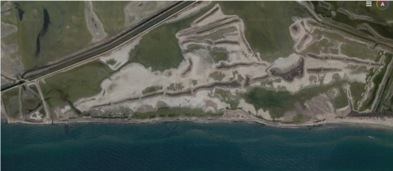
Dyke Quenin
The second issue in this region is the dyke Quenin, see image. After building this dyke, the beach has almost disappeared and breaches occur frequently. Recently, rocks have been placed on the rear side to protect the dyke. However, this does not stop the dyke from breaching or being damaged by the sea. The question is what the solutions are to maintain this dyke. Some possible solutions are a wave attenuator, heightening the crest or strengthening the rear side for example by adding vegetation. Currently, some tests are being done on various kinds of Mediterranean vegetation types. After analyses have been finalised concerning the risks of overflow for the various solutions, proposals for this dyke will be done.
Solid deposit of the river Rhône
The third and final issue for the Salins region is solid deposit of the river Rhône. Until the 18th century there was another mouth of the Rhône which has moved to the east over time. This caused the Rhône not bringing any solid deposit to the area of Salins. The question is now what could be done at the mouth of the river. Based on the experiences of the Japanese and Dutch, the French started analysing the symmetry of the solid deposit. From these analyses the conclusion is drawn that some more deposits on the west side are preferable. Salins is looking at what can be done to solve this problem.
Meanders of river threat to dunes
In the North of France, in an area referred to as CA2BM, from the Bay of Authie near Berck sur Mer the dunes are not threatened that much by the sea, but more so by the meandering of the Authie river. The last severe erosions were in 2011 and 2018 or 2019. Dunes eroded and fir trees were carried away by the river. This is a problem as the dunes are a natural coastal defence for the hinterland that mainly lies below sea level. To solve this problem, the partners have installed a system of sand nets controlling these meanders. Observations and numerical modelling have shown that the sand nets have an impact on the meanders of the river, can control the meanders and lead to an increase of sand deposits.
Safe development between dykes and mountains
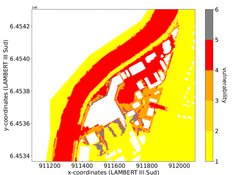
In Grenoble the question is how can we simultaneously assure safety and development of a city located between dykes and mountains? In France there is regulation to determine safety width. This is usually 100 times the reference height, which is the flood event reference level with a frequency of 100 years. In the area that falls within this safety width nothing should be built. However, this is difficult for some areas in France, for example in Grenoble which is situated between dykes and mountains. It is not possible to develop and build without building in the safety width. The issue is the vulnerability of buildings behind dykes.
With French experts some levels of vulnerability have been determined concerning the damages on buildings and types of building that match these vulnerability levels. Based on these data vulnerability maps, see image, can be designed indicating what location and type of build is best to use.
System of embankment
The final issue concerns the system of embankment. The low areas of Bay of Somme in France know a system of embankment, which is a system of several dykes with first and second lines of protection. The area of Bay of Somme and Bay of Authie is protected by dykes on each side. The question is to develop a risk assessment at regional scale. All the risks are assessed locally rather than regionally in France. The goal is to develop a model that can be used for a larger area based on state-of-the-art techniques.
Watch full presentation
These are the issues and possible solutions that these partners in France are currently working on. For more detailed information and the full presentation of Philippe Sergent, watch the video.
Credits:
Thanks to N. Huybrechts, V. Laborie, B. Bader and A. Poupardin for their contributions.
Cerema and Polder2C’s
Cerema’s contribution to the Polder2C’s project is quite broad concerning Flood Defence, Emergency Response and Knowledge Infrastructure activities. Some examples of activities Cerema is involved in are Inspection Exercises, Emergency Response Exercises, an Action Plan for Collaboration and a Lessons Learned Report.