Animal Burrowing
One of the most common discontinuities on levees that are reported by levee guards during visual inspections is animal burrows.
Not a lot is known yet about the structure, size and number of animal burrows and their impact on levee strength. As the Polder2C’s project could use two existing levees safely for all kinds of research questions, the project team seized this opportunity to include animal burrowing in the project.
Risk of animal burrows for levee stability
How risky are the animal burrows on the levee stability? How do they affect you? Animal burrow systems can vary in size and spatial layout depending on the animal that has created them. Burrows that are created by relatively large animals, such as foxes, rabbits and beavers are easier to detect in a visual inspection and they are considered dangerous for the structural integrity of levees. Burrows that are created by smaller animals, like mice, are more difficult to detect, but they are perceived as less dangerous.
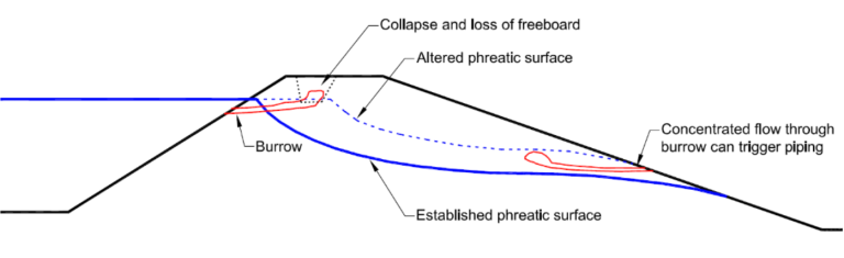
Figure: Effects of animal burrows in levees (Cobos Roa, 2015)
During levee inspection exercises organised by Polder2C’s, it became clear that there is no consensus among levee management authorities on the level of risk that various types of burrows pose on a levee. Risk evaluation relies on individual assessments by levee guards and can vary substantially among individuals with different experience, from different authorities or from different countries. Apart from this, it was also noticed that current practices are mostly informed by the experiences of local levee guards that are largely unreported and are not systematically compared to scientific findings.
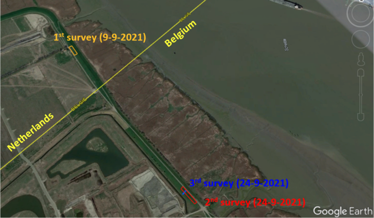
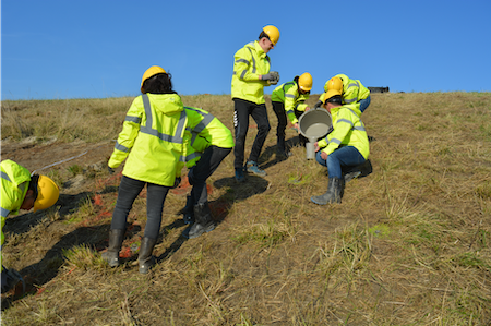
On 8th September 2021, an animal burrows survey took place in the Living-Lab Hedwige Prosperpolder whose purpose was to collect data in a coordinated manner, hence contributing to future efforts to address the above-mentioned issues. The objectives of the activity are summarised below:
- Gain insight into the types of animals that are active in the living lab as well as the geometry and spatial distribution of the burrows they create on the levee.
- Monitor the levee inspection process and derive lessons that can improve the practices of levee guards.
- Test feasibility and compare results of two methods for evaluation of burrows; the ground penetrating radar and the smoke method.
- Identify locations with burrows that could be tested later on, in a large-scale overflow experiment.
- Compare findings from the application of different survey techniques and draw lessons for their future use.
After the first winter of experimentation in the Living Lab Hedwige-Prosperpolder, evidence was produced about the possible adverse impact of animal- and vegetation-induced discontinuities on levees (Hölscher & Zomer, 2021; Koelewijn et al. 2021). Overflow experiments at locations of anomalies caused by grazing sheep, trees, and fox holes led to severe erosion of the structure within a considerably short time.
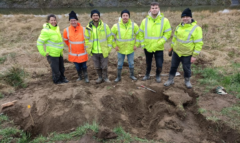
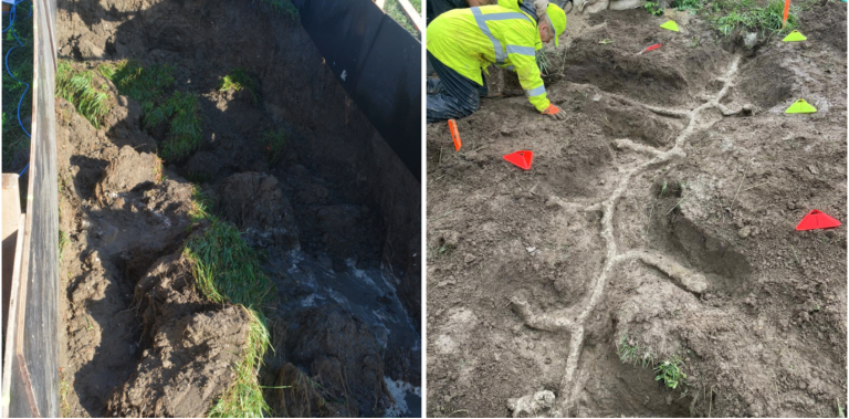
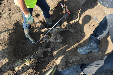
In June 2021 a mole burrow system was detected in a levee section that had been damaged during overflow experiments and where an emergency repair application with rock bags had been subsequently applied. In order to explore the geometry and extent of the system, the mole tunnels were grouted with fast-drying concrete. Upon excavation of the concrete, an extensive burrow system was revealed with exit points close to the toe and close to the crest of the section.
Left: Foxhole on the Hedwige levee after overflow testing on 23 November 2020. Test conditions: discharge of 180 litres per second in a 2-metre-wide section for 1hour and 13 minutes (Source: Koelewijn et al. 2020).
Right: Excavation of tunnel system created by mole activity, after filling it with fast-hardening concrete (Source: Hölscher & Zomer, 2021).
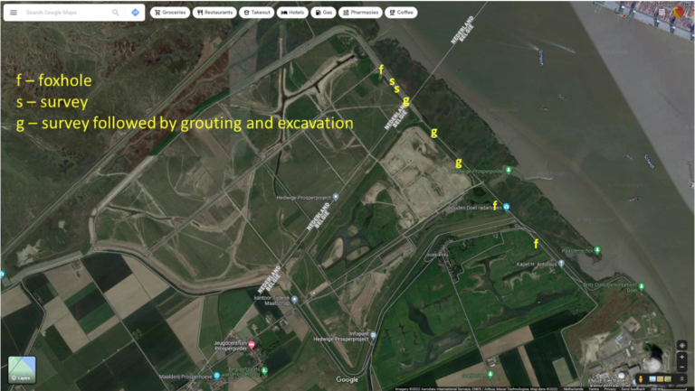
The Location & Levee Geometry
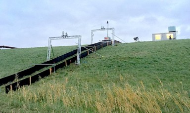
The survey was performed on the levee stretch where overflow experiments were scheduled to take place in the upcoming experimental season, starting in November 2021. This location allowed the identification of burrows that could be tested against overflow. The selected stretch is situated on the Hedwige levee, i.e. the Dutch side of the living lab, and specifically on the southeast of the concrete staircase situated in front of the former farm house of De Cloedt (see also Figure 1, left). On the Dutch levee there is an asphalt road at the inner toe of the structure (see also Figure 1, right). The team gave priority to the survey of the inner slope as this is the slope that would be tested later against overflow. Although the survey of the outer slope was considered equally interesting for the rest of the objectives of the study, it was excluded due to time limitations.
Mapping
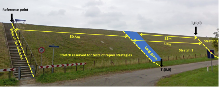
Based on the final number of participants, it was deemed realistic to focus on the survey of the inner slope only, and to aim at covering a levee stretch of about 100m from crest to toe. Upon arrival on site the team determined the boundaries of the survey area. The southeast edge of the staircase at the point that the crest meets the inner slope of the levee was selected as a reference point for the paper mapping. The survey boundary was set 80.5m to the southeast of the staircase (see also Figure 6). The first 80.5m adjacent to the staircase were reserved for testing various repair strategies and a major intervention had already taken place (see also Figure 7). This was an unconventional levee stretch and was considered outside the scope of the survey, so it was excluded.
Animal Burrows Clues
How can we spot burrows?
- Look for clusters: If you spot one burrow, look for more burrows within a radius of 5-10m.
- Look for vertical lines of burrows: Some small rodents move underground in a linear fashion from crest to toe (e.g moles).
- Look for mounds of clay or patches of sand: Excavated material can be found on the surface when the burrows are new.
How can we find out the geometry of underground tunnels?
The smoke test: Tested and improved
Key findings
- Allows identifying burrows that belong to the same system
- Versions 2 and 3 are both usable with certain pros and cons
- Can be complementary to visual inspection
- Degree of success in different soil conditions not fully understood (further research needed)
- Effects on the health and safety of animals are unknown (further research needed)
Ground Penetrating Radar
Key findings:
- Interpolation of transects allows a 3D-approximation of subsoil discontinuities (ongoing research)
- To do: comparison with grouting results from the same location (not part of Idsinga’s study)
Electric Resistivity Tomography
- Applied for the first time to monitor mole burrows system during an overflow test
- Qualifies as an innovative solution
Grouting and Excavation
Proved to be a good way to find the extent of the burrows and the interconnections of different holes and entrances in the levee.
Read more on the research activities into animal burrowing in an earlier news article.