Erosion Tests
Our Living Lab Hedwige-Prosperpolder has been in full use for some years. We have carried out various field tests at our site, mainly to see how strong the levee cover is and which factors determine the strength. This was studied by carrying out the overflow and overtop tests. As these tests have now been finalised, it is time to share the results.
Erosion Tests
What is the impact of environmental elements such as the weather, the presence of vegetation, or man-made objects on our flood defenses?
To answer these questions numerous destructive field tests, erosion tests, have been carried out in the Living Lab.
Types of erosion tests
During the erosion tests, the levee was exposed to increasing loading conditions, imitating an extreme storm event by the use of pump-driven simulators as well as prevailing tidal conditions until failure occurs. The following test types are considered:
- Wave overtopping
- Steady/continuous overflow
- Wave impact
- Breach growth
Unique Chance
The unique location of the levee, on either side of the border between the Netherlands and Belgium, is very interesting. The various choices in Flanders and the Netherlands regarding the design and maintenance of the levee can therefore also be examined in the study. Researchers tested the influence of differences in material, vegetation, and management on levee strength. Belgium and the Netherlands have made different choices here.
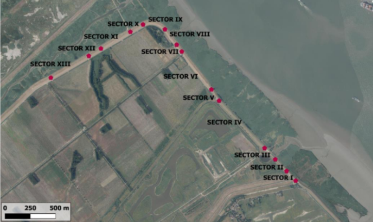
Image: bird view of the Living Lab Hedwige-Prosperpolder indicating the locations of erosion tests
The Survey
One of our goals is to find out what the current state is, a T0 baseline, of our levee condition. This is required to evaluate impact of the tests in relation to the parameters that characterise the levees, as there are differences in structure, slope and vegetation. The data that are needed to form a baseline dataset are gathered by survey. Based on all the data we will make a digital twin. This is a computer model of the levee which can be used as a data source to simulate experiments.
The following data sets are required:
- Detailed geometry of the levees.
- Geotechnical and sedimentological properties of the top soil and deeper structure, properties of the cover layer including vegetation and animal burrows.
- Morphological defects, such as burrows or wet spots.
- Hydraulic properties of the levee structure.
Large scale tests
We organised two large scale tests to be performed on the clay.
The first test was an overflow test. The second one was a wave overtopping experiment.
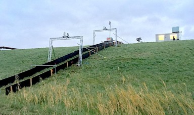
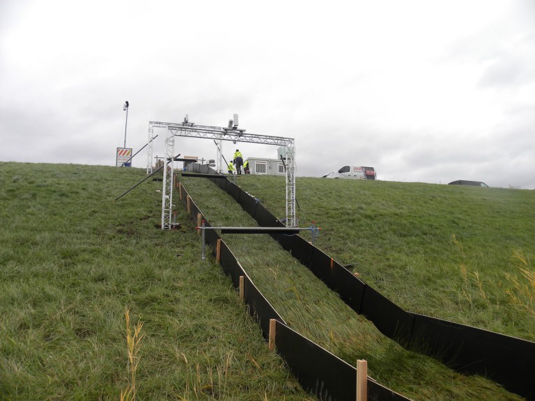
1. Overflow Tests
To carry out the overflow tests, an overflow generator was installed on the river side of the levee in the Hedwige-Prosperpolder. This is a set-up that can simulate overflow of the levee with water. The water is supplied to the generator via pumps. A fixed amount of water flows down the landward slope of the levee via a demarcated test strip. The tests are carried out to determine the erosion resistance of the vegetation and cover layer. The effect of the amount of water is studied, but also of other factors such as animal activity, the type of covering and, for example, the presence of a tree.
>> See the 3D model of the water overflow test set up
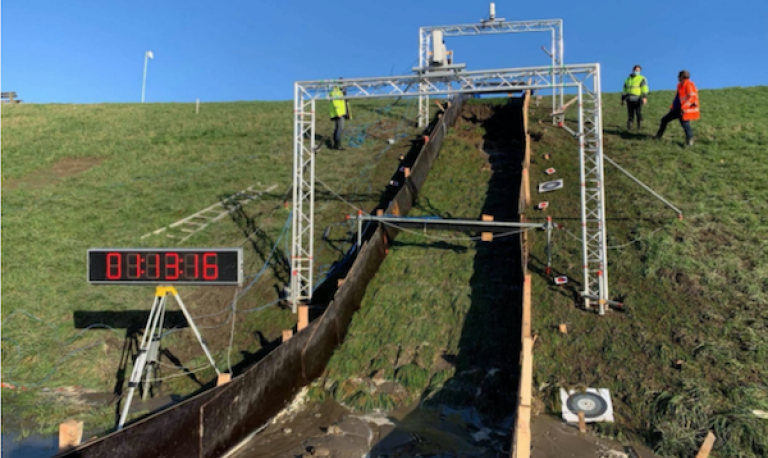
During the overflow test we removed the grass cover over a section. Using pumps we simulated the overflow conditions over a levee. The erosion was tracked during the experiment. The experiment was performed on the same section as where before a grass cover was tested for the erosion resistance. The clay was therefore quite saturated at the start of the experiment. Based on the outcomes of the Jet Erosion Tests and the tests with the Erosion Function Apparatus we anticipated significant erosion of the clay around 20L/s/m. However, even after applying a maximum discharge of 1m3/s we did not find any erosion of the clay indicating an interesting discrepancy between what you would expect to see happening based on the outcome of small-scale tests and what you witness seeing happening at large-scale.
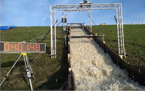
2. Overtopping Tests
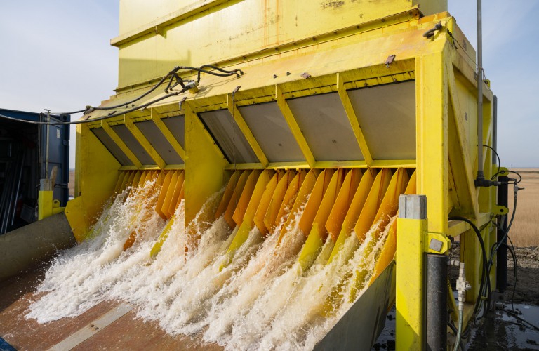
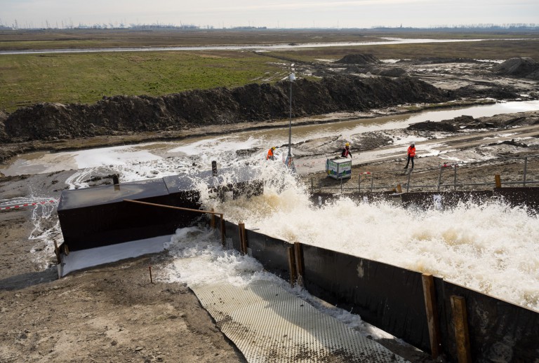
We also performed large scale wave overtopping experiments on the clay. A wave overtopping simulator was placed near the top of the levee. Intermittently it released large volumes of water across the landside slope of the levee, thereby simulating the effect of waves overtopping. Real storms tend the be characterised by numerous waves of different height, causing for highly irregular patterns in wave overtopping. You can imagine that releasing different wave volumes from the simulator would make it difficult to relate the amount of erosion measured to the load exerted on the levee by the waves.
In order to develop a relation between the load exerted by a wave volume and the amount erosion resulting from it, we released regular waves as well. The regular waves were used to calibrate an erosion relation. In order to verify that the resulting erosion relation would also be valid under more natural conditions, also tests were performed with the more realistic irregular wave patterns. Between the wave releases the changes in the shape of the landside slope were carefully captured using multiply camera’s. This resulted in a full 3D image of how the slope changed with time.
Erosion Survey
The survey activities served two purposes. First, results are needed to support the design of a full-scale test, and second, the results would be used to translate the outcome of full-scale tests to other levees. We wanted to ensure that the results from large-scale tests obtained at the Living Lab Hedwige Prosperpolder could be translated to other levees.
In line with our focus on erosion, we initiated the following activities
- Jet Erosion Tests: These tests have slowly become an international standard in identifying the relative erosion resistance of clay. During overtopping conditions the waves or overflow induces stresses on the clay which causes it to erode. We wanted to use these small-scale tests to learn how clay may erode as a function of normal stresses exerted on it. The disadvantage of the JET is that it solely induces a jet stream on a very small section of the clay. Clay is often not very homogeneous at this small scale causing a large spread in results. Although it is therefore difficult to quantify the erosion characteristics based on one small-scale test, it does offer significant insights in the relative erosion resistance of clays. When repeating the tests on another levee the results might be used to determine whether the other levee is more or less erosion resistant. If it is more, then the predictions of the amount of erosion are likely to be conservative and therefore could be used with confidence.
- Tests with the Erosion Function apparatus: During overtopping, clays are subjected to normal stresses and shear stresses. We attempted to identify the behavior of clay during normal stresses from the results of the Jet Erosion Test. By testing the clay as well with the Erosion Function Apparatus, we also managed to identify the erosive behavior of clay under shear stresses.
- Profile pit: We considered that a visual inspection is still very valuable when identifying the soils present at a site. After identifying the locations where we wanted to do some large-scale tests on the clay, we excavated the top layer of the soil over a depth of 1m at either side of the test location to identify how the levee was built up.
Erosion Photogrammetry
This interesting method uses a combination of photos taken of an object from different angles to construct a 3D image from which changes in geometry were derived. Photogrammetry was applied in order to monitor the changes in levee profile during overtopping thereby contributing to knowledge around erosion resistance of clay under wave overtopping. Consequently, by tracking the change in the state of the levee protection layer it provided valuable data needed to develop and validate the erosion tool.
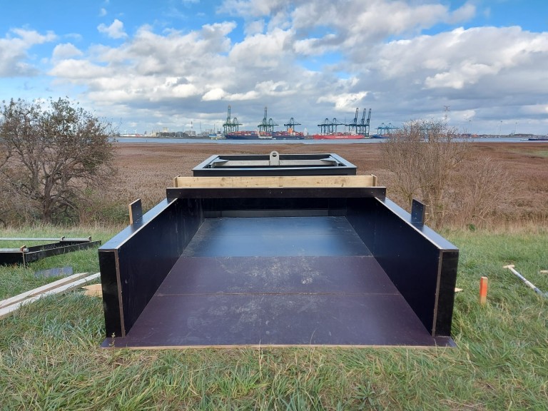
The erosion study area was photographed with 10 GoPro Hero 9 cameras syncretized together. To provide full coverage of each test subsection (with dimensions of 4 m*3.5 m) as well as enough overlap between photographs, a fixed frame supporting ten cameras, was installed in the middle of the testing zone. Six cameras were installed over the entire width of the section over a horizontal rod. The rest four cameras were positioned on the lateral frame piers.
"Before a levee has fully breached, a lot of processes need to occur."
On the other hand, to specify locations within the scene as well as to set up a coordinate system, some fixed points called Ground Control Points, were installed on the guiding channel walls of the section horizontally and vertically and their exact position was measured using the GPS. The cameras take pictures each second thanks to a pre-setting time-lapse mode including the initial and final situations for each wave's batch. Moreover, to guarantee sharp pictures of the ground surface instead of an invisible ground through the waves, after each wave batch the flow to the simulator is interrupted for 60 seconds.
The work was realized by aligning a set of ten images each time to reconstruct the temporal and spatial morphological evolutions of test zones. Ultra-high resolution Dense Cloud and Digital Elevation Models (containing XYZ coordinates) were extracted from the post-processing software (Agiosoft Metashape) for further analysis.
Research into Erosion Resistance
This showcase aims to inform you of the activities that were planned to learn more about the erosion resistance of levees. You may already feel nervous seeing a levee overflow or overtop. However, before a levee has fully breached, a lot of processes need to occur.
First the cover layer, often consisting of grass has to erode, or be undermined. Once the cover layer is gone still a large body of material is left which takes a long time to erode. However, if levee managers want to feel that they are in control it is recommended to test how the levee behaves under more controlled conditions. When thinking about the resilience offered by levees, we identified the problem that little is known about the erosion resistance of clay covers once the grass cover has been damaged. After a long dry summer, after a certain duration of wave overtopping, or due to external factors, the grass cover on a levee could get damaged. In that case the erosion resistance offered by the clay layers in levees is of vital importance to prevent the formation of a full breach.
Photos: Wave overtopping machine and test in the Living Lab Hedwige-Prosperpolder
Although some information is available on how to categorise clay based on it erosion resistance, we noted that actually little is known on how rapid clay will erode when subjected to wave overtopping of overflow. Addressing this challenge also performed a challenge for us as solely performing a test to determine the erosion resistance of the clay in the Living Lab Hedwige-Prosperpolder would only provide information on the erosion resistance of the clay available at the site. At that moment it would be difficult to translate these results to other levees. For that reason a series of activities were aligned to learn more about the erosive properties of clay. These activities consist of survey activities, large scale tests and model development.
Want to know more
Read more about the various series of erosion tests in the articles below: