De Vlaamse Waterweg: Sigma Plan protecting Flanders against flooding
- 01 February 2023
- Francien Horrevorts
How can you protect a densely populated area from storm floods? And how can you make nature work for you and combine safety and nature development? Patrick Van Bockstal, Director River Management at De Vlaamse Waterweg, will enlighten you. He explains more about the Sigma Plan, which aims to protect a large area in Flanders against storm floods.
De Vlaamse Waterweg
De Vlaamse Waterweg strengthens transport via inland shipping, ensures water management and increases the attractiveness of the waterways for recreation, tourism and nature experience. The four main tasks of De Vlaamse Waterweg are:
- Maintenance and development of the waterway network and its assets
- Stimulating transport over water to improve the mobility in Flanders
- Water management
- Facilitate and stimulate other functions such as recreation
The Sigma Plan
Heavy storms and wind surge can cause very high water levels in Antwerp and upstream along the river Scheldt. In the past this has led to severe and uncontrolled flooding, such as in 1953 and 1976. These incidents were the reason for initiating the original Sigma Plan in 1977. Sigma stands for the “S” in river Scheldt.

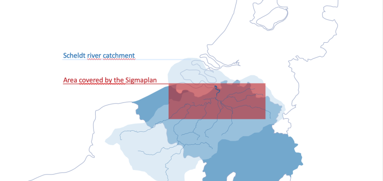
Fig: Area covered by Sigma Plan
The Sigma Plan covers the tidal part of the Scheldt river catchment, situated in Flanders, Belgium. The original Sigma Plan contained three measures for better protection against the storm floods:
- Strengthening and raising the level of 500 kilometres of embankments
- Building 13 controlled flood areas (1,130 ha)
- Building a storm surge barrier in Antwerp
In 2000 the first goal was mostly reached and 12 of the 13 controlled flood areas were constructed. In 2015 the last and biggest controlled flood area with a surface of 600 ha was also finalised. However, the final measure, the storm surge barrier in Antwerp has never been realised, due to a negative cost-benefit analysis.
Controlled Flood Areas
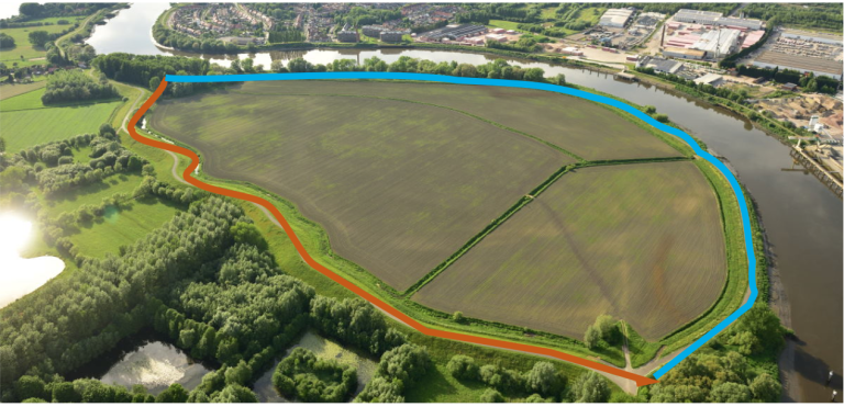
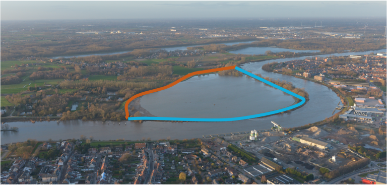
Controlled flood areas typically consist of three important elements: a ring dike surrounding the area, a lowered and reinforced existing river dike that is transformed into an overflow dike and finally a discharge sluice in the overflow dike. When a storm tide occurs, the water will flow over the overflow dike into the controlled flood area but it will be confined by the ring dike. After the storm the sluice enables the water to flow back to the river.


Photos: Controlled flood area, normal and storm tide. Red is the ring dike and blue Is the overflow dike
Updating the Sigma Plan
Due to several new insights and developments, an update of the Sigma Plan was necessary. Among these reasons were a new vision on water management that instructed more space for the river, and the effects of climate change, such as the rising of the sea level. The updated Sigma Plan was approved in 2005. The new plan consists of more than forty project areas and the ambition is to finalise the updated Sigma Plan in 2030.
Nature based solutions
As part of the updated Sigma Plan, nature based solutions are preferred. In this context this concept refers to sustainable management and the development of nature while tackling the challenges of water management and flood defence.
The philosophy
The philosophy of the Sigma Plan is to work with nature, not to fight nature. It has been decided to create more space for the river, restore and enhance the ecological processes and involve the stakeholders. Therefore, what is needed:
- A good understanding of the hydrological and hydrodynamic processes to select the best measures
- The integration of the ecological processes in the design of the measures
- A combination of top down and bottom up approaches in stakeholders’ involvement

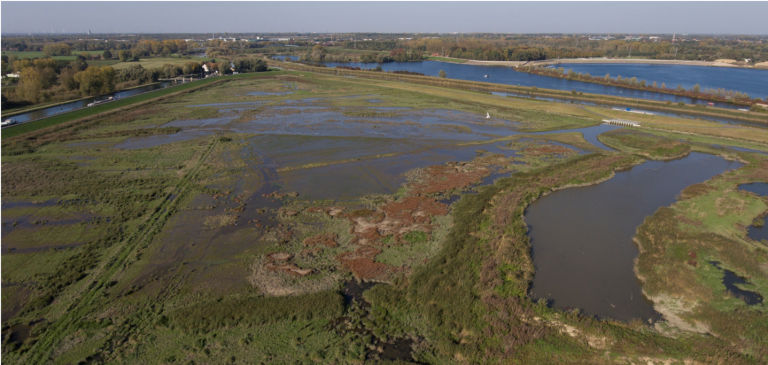
Photo: Zennegat, Mechelen - Flood control area with reduced tides
New concepts
Some new concepts are introduced as well, such as flood control areas with reduced tides.
This concept combines safety with nature development. During the last century, a lot of the low dynamic tidal nature such as mudflats and marshes have disappeared. Now, this type of nature is being restored by creating controlled flood areas, where mild versions of the tides are imitated. An inlet and an outlet (or discharge) sluice are installed. Twice a day, a small amount of water flows in and out of the area on the rhythm of the tide. This results in the creation of tidal nature with mudflats and marshes.
"We are very proud of the recognition of Sigma projects, showing how the goals of safety, nature development and navigability can come together."
Patrick Van Bockstal
Recognition for Sigma Plan projects
Several projects of the Sigma Plan have not gone by unnoticed. In May 2018 the Flemish Waterways, the Agency for Nature Development and International Marine and Dredging Consultants (IDMC) won the third price for the PIANC, Working with Nature Award for the project Kalkense Meersen. Also, in January 2019 the Sigma projects of Polders van Kruibeke and Kalkense Meersen are selected by the United States Army Corps of Engineers (USACE) as an example in their Atlas on Engineering with Nature.
Full presentation
For more detailed information, watch the full presentation by Patrick van Bockstal:
More information
To learn more about De Vlaamse Waterweg, what they do and their role in Polder2C’s, read the interview with Patrick van Bockstal.
