Incident Management and Natural Flood Management explained by the Environment Agency
- 11 November 2021
- Francien Horrevorts
Do you know what types of incidents the Environment Agency manages and what Natural Flood Management entails? Faye Lynch and Geoffrey Foulkes of the Environment Agency addressed these topics during one of our partner meetings. Read the summary or watch the full presentation.
Faye Lynch, Project Manager, explains about the work of the Environment Agency and the different types of incidents they handle. The Environment Agency is the largest organisation protecting and improving the environment in England. They are an independent organisation but work with the government very closely to get the best possible results for the environment.

Incident Management
As partner of the Polder2C’s project, the Environment Agency is especially known for its expertise in Flood Work. However, they also work on various other topics such as regulating major industry and waste, treatment of contaminated land, water quality, habitat conservation and ecology. Incident management also takes up a lot of the Environment Agency’s attention, where every 45 minutes an incident is reported that needs attending to. Most of these incidents are environment incidents, for instance pollution of land, water and air, drought management or marine incidents. Only 8% of the incidents are flood incidents, which involve monitoring and forecasting, deploying flood defence assets and informing the public and partners.
Concept of Operations
The Environment Agency manages both environment incidents and flood incidents in a similar way, following a procedure, the concept of operations (ConOps). The key principles related to ConOps are that it applies to all incidents of all scales in severity. It is used as a framework to escalate and scale the activities according to the nature and size of the incident.

Geoffrey Foulkes is Deputy Catchment Engineer at the Environment Agency. He introduces a project that he has been working on as Project Manager recently. This is the Dorking Natural Flood Management Scheme.
Natural Flood Management - NFM
What is Natural Flood Management (NFM)? It involves implementing measures to restore or mimic natural functions of rivers, floodplains and the wider catchment. It works by storing water in the landscape and slow the rate of which water runs off the land into rivers. This can be done by four main routes; slowing flowing water, storing water, increasing soil infiltration or intercepting rainfall. NFM is a relatively new approach which the Environment Agency has trialed in a few locations around the UK. One of these trials is in Dorking,
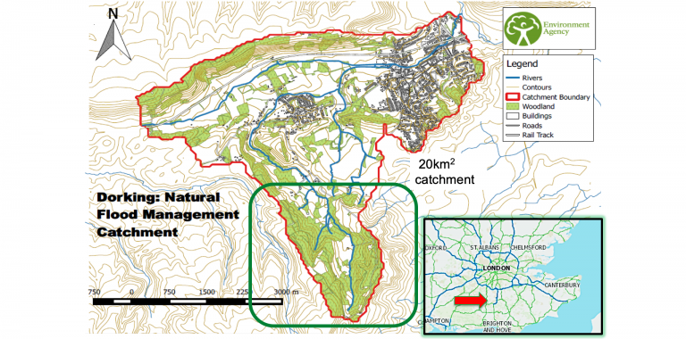
Dorking Natural Flood Management Scheme
Dorking is a town south of London. The area that was included in the project was an area of 20 km2 around the Pipps Brook, a tributary of the Mole river, where the catchment has been identified as having an influence on how flooding progresses within Dorking town itself. Implementing a scheme in this area was suspected to have a positive effect on flooding.
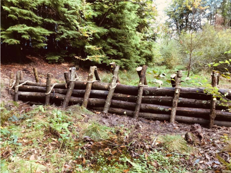
Leaky log dams
The scheme involved the installation of leaky log dams made of timber across the channel and floodplain. Leaky log dams are placed in locations where they are able to capture and hold back runoff water from the catchment. They are also designed to leak and hence, slow the amount of water flowing downstream. This allows time for the water in rivers downstream to reduce in volume before water from our selected streams arrive. As such, the volume of water in the downstream river is spread over a longer period of time – reducing river levels and hence flooding.
Project benefits
So far the benefits of using NFM are:
- Increased flood protection
- Environmental habitat improvement
- 66% carbon saving during construction
- PhD research outcomes of the project
- Cost reduction of 90% compared to hard engineering approach
Early data show excellent results
The project is being monitored via sensors and cameras and a PhD student is carrying out research as to how well the new technique is reducing flooding downstream. Data obtained so far have shown the leaky log dams to have reduced the peak of the hydrograph, as well as spread the discharge flow over a longer period of time. This has resulted in lower river levels that would have otherwise caused flooding in Dorking town. As such, early data indicates that the interventions are effectively slowing the flow of water from the tributary into the main river downstream.
The 6 year PhD study will monitor the condition and operation of the structures, as well as other local factors such as rainfall distribution, runoff from local flora, and impacts on the forest habitat. In addition, the level loggers and fixed-point photography are going to be linked into our internal monitoring systems, meaning that data collection does not have an end date and we can continue to learn lessons after the PhD study is completed.
An animation generated by computer modelling was created to better understand the following 3 aspects of the structures: the mechanism which causes the leaky log dams to retain high flows, the behaviour of water which has been forced out of the channel and onto the flood plain, and how this water re-enters the watercourse.
Watch full presentation
For more detailed information and the full presentation, watch the video.
Read more
You may also like the interview with Jim Barlow about the role of the Environment Agency in the Polder2C’s project.